Mayor Mike McGinn was live from NE Ravenna Blvd Wednesday morning at 11 AM for a “Ravenna Blvd Paving and Road Maintenance Update.” Watch the archived video below:
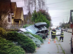
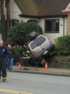
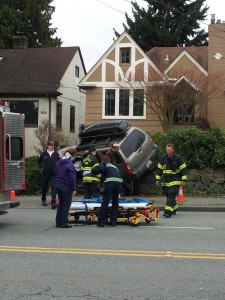
Collision on 25th Ave NE sends SUV into yard (PHOTOS)
At approximately 2:17 PM, Seattle Fire Department units responded to a Heavy Rescue call just south of the intersection of NE 65th St and 25th Ave NE. A car and an SUV had collided, sending the SUV up over the sidewalk on the west side of 25th Ave NE and onto a residence’s front yard.
Seattle Fire Department PIO Kyle Moore said that one person was taken out of the SUV and was conscious. A bystander at the scene reported that the SUV occupant “was going off in a neck brace in the ambulance,” and that the other car “had damage to the left rear quarter.”
Thank you to Duncan, John, and Eric for their information gathering assistance for this post.
If you HAVE to drive in snowy Northeast Seattle, here’s how (UPDATE)
Whether you’re putting your trust in the National Weather Service or UWÂ Professor of Atmospheric Sciences Cliff Mass, there’s no denyin’ that there’s gonna be more snow in the next couple days.
In case you need to travel to and/or from Northeast Seattle during the snow, you’ll want to know which roads are being kept clear by Seattle Department of Transportation (SDOT) crews, and which are not.
To the right is a portion of SDOT’s snow map, focused on Northeast Seattle (full map here; 810 KB PDF). There are three different street service levels assigned to those arterial streets which are the busiest, connect neighborhoods with downtown, are used by transit and public safety agencies (police, fire), and reach schools and hospitals.
These different levels are to let users know which routes are being serviced and what conditions to expect. They are not prioritized — road servicing is ongoing at all levels as needed.
The different levels as shown on the map are:
Level 1 (yellow) -ALL lanes bare and wet
Level 2 (blue) – ONE lane each direction bare and wet
Level 3 (green) – Curves, hills and stopping zones treated
You can find Seattle’s Winter Weather Readiness and Response Plan here, which includes road treatment descriptions, facility and fleet information, links to city communication tools, and more.
As for tips on how to drive in the snow, the Washington State Department of Transportation (WSDOT) has a few to read, or watch on YouTube.
Take Winter By Storm’s website has lots of checklists you can use to be fully prepared both on the road and at home.
And then there’s PEMCO Insurance’s “The right way to abandon your car in a snowstorm.” You may want to print that one out to stick in your glove compartment, just in case.
____________________
UPDATE (Wednesday, 9:43 AM): City Councilmember Sally Bagshaw just tweeted out a great link for those us us curious about road conditions in Northeast Seattle AND citywide.

SDOT's Winter Weather map page (static screengrab taken Wednesday morning) -- click to go to the site
SDOT’s Winter Weather map shows which streets have been treated and/or plowed, and how long ago they were last serviced.
Different parts of the city can be selected from a dropdown menu at the top-right of the page (“Select Neighborhood”). Different road service levels are shown in different colors, as well as the different types of service (liquid de-icer vs. plows with and without salt spreaders).
Nifty map aside, we recommend drivers check out road conditions locally for themselves before heading out.
Rally and march near Montlake, University Bridges this afternoon (updates)
This afternoon, the 99% are coming north of the cut.
A rally and march are planned for the University of Washington area, starting at 3:30 this afternoon.
From Working Washington’s facebook page for the event:
On November 17, people from across the area will converge at the functionally obsolete Montlake Bridge to demand our political leaders build bridges to good jobs, not make more cuts. This is part of a national day of action for jobs that’s happening in dozens of cities across the country.
The schedule of events today appears to be:
3:30 PM – Gathering at the grassy area just west of the intersection of Montlake & Pacific
4:00 PM – Rally
4:30 PM – March
One possible route the march could take we’ve gleaned from the website The Stand, a project of the Washington State Labor Council, AFL-CIO (WSLC) and its affiliated unions. The Stand describes the march route as starting near the Montlake Bridge, but ending at the University Bridge to the west, due to “safety concerns cited by the Seattle Police Dept.”
A call to the front desk at the North Precinct reveals no final march route plans in place at the time of this writing; however, the officer on the phone said “they’re having a big summit on it right now.”
Capitol Hill Seattle echoes the march route move to the University Bridge, citing a Thursday Day of Action itinerary (at the bottom of the post).
UPDATE (12:14 PM): The Seattle Times’ Today File confirms the move to march to the University Bridge instead of to Montlake, citing the information on The Stand’s website that we mentioned earlier.
View November 17th rally and march in a larger map
UPDATE (12:21 PM): The Seattle Department of Transportation has sent out the following traffic advisory (via email):
SEATTLE An Occupy Seattle rally and march today has the potential for creating major delays on all arterials leading to and from Ship Canal bridges during the afternoon commute.
The rally is scheduled to take place between 3:00 and 4:00 p.m. on the University of Washington campus and then is expected to march west on NE Pacific Street to the University Bridge at roughly 4:30 p.m. The demonstrators plan to block the bridge during the afternoon rush hour so their presence will likely cause traffic delays throughout the afternoon commute until after 6:30 or 7 p.m. Demonstrators may also block the Montlake Bridge during that timeframe.
Seattle Police Officers will be on hand to minimize traffic congestion but the blockage of any one bridge could impact other nearby Ship Canal bridges. Commuters should allow additional time for detouring to another route. Motorists who must get to the University or Children’s hospitals should plan for extra time to reach their destination.
The protests could be very disruptive to transit service this afternoon. For information or questions about transit service, please call Metro Transit customer service at 206-553-3000, and sign up to receive Transit Alerts at www.kingcounty.gov/metro/alerts.
UPDATE (2:44 PM): The Seattle Department of Transportation has a network of traffic webcams across the city, and there just happens to be one at Montlake Blvd NE @ NE Pacific St (first picture revealed after you click the camera indicated by the picture below).
This rally and march is part of a larger “Mass Day of Action” planned for today, with events happening all around the country.
Two fatalities, three serious injuries after crash on 110th and Lake City Way (updates)
UPDATE (Tuesday, December 6): SUV driver has been charged with two counts of vehicular homicide, one count of vehicular assault and one count of reckless endangerment. (Seattle Times)
UPDATE (Thursday, November 17): The Seattle Times’ Today File reports that the SUV driver has left the hospital, for jail.
UPDATE (Tuesday, 2:09 PM): The Seattle Times reports that the man driving the SUV in Sunday’s crash was charged in 2009 with vehicular homicide.
UPDATE (Monday, 6:32 PM): The Seattle Times’ Today File has information about the victims of the crash.
UPDATE (Sunday, 7:38 PM): More info on the Seattle Police Department Blotter here, including news that the injuries to the people taken to Harborview were non-life-threatening. Also, the accident detour will last until approximately 9 PM.
____________________
Just after 4 PM on Sunday, November 13, Jonah Spangenthal-Lee (via SeaCrime on twitter) mentioned a “[b]ad accident with possible fatalities on 110th and Lake City Way.”
View Fatality accident at 110th and Lake City Way in a larger map
Since then, as details have come in, the story has turned even more tragic.
KING 5 News is reporting that two people have died at the scene, and three others have been taken to Harborview Medical Center.
Police say one car was stopped when another vehicle, an SUV, hit the car from behind.
The car caught fire as it was pushed down the street. Two people in the car were dead at the scene.
The male driver of the SUV was transported to Harborview Medical Center with life threatening injuries
Two girls in the back seat of SUV were also transported to Harborview with serious injuries.
The Seattle Times reports that the injured girls were a 10-year-old and an 20-year-old woman 11-year-old girl.
Updates will be available here at KING5.com and on The Blotter on seattletimes.com.
Obama-cade: The video!
President Obama’s motorcade heads down NE 75th Street through Ravenna and into Wedgwood for his Seattle Backyard Conversation.
Filmed from the corner of 23rd Avenue NE and NE 75th Street:
15th Ave NE and the Scramble – Local Road Work for 2011
The NE 45th Avenue viaduct project is almost done. Huzzah! Construction is due to be completed on September 10th, just in time for the first Husky football game the next day.
There are a few more viaduct projects to finish in October and November — lighting installation, finalizing the line striping and pedestrian markings, and replanting the surrounding area — but the detour will be no more, and life will return to normal…
…until January of next year, when two new construction projects are headed our way.
The Big One: 15th Avenue NE Reconstruction – NE Pacific Street to NE 55th Street
I’m sure we can all agree that the surface of 15th Avenue NE is a pothole-riddled disaster, and the increased traffic from the viaduct detour route isn’t doing it any favors.
Happily for us, the Seattle Department of Transportation (SDOT) has plans in the works to reconstruct most of 15th Avenue between NE Pacific Street and NE 55th Street between January and October of 2011.
This popular arterial will be FULLY RECONSTRUCTED between NE Pacific Street and NE 50th Street between January and September, while the stretch between NE 50th Street and NE 55th Street will just get a repaving. Intersections at NE Pacific Street, NE 45th Street, and NE 50th Street will not be repaved as this was done more recently.
And there’s more! From the SDOT’s 15th Avenue Reconstruction Project website:
Other improvements include:
- New curb ramps and curb bulbs to improve pedestrian mobility
- Sidewalk widening at bus zones (bus bulbs)
- Drainage upgrades
- Installation of a new marked crosswalk at NE 41st St
- New northbound left turn lane at NE 42nd St
- Upgraded street lighting system
- New electrical infrastructure for future transit improvements
- Transit improvements including
- North to west turn restriction from 15th NE to NE 45th during some or all of the day
- Expanded bus stop waiting areas (bus bulbs) at two locations
- Bus stop consolidation where stops are too close together
All great stuff. But the area is going to be a general mess during the construction. Trolley wires will be turned off on weekends to accommodate construction needs. This means diesel buses will be traveling through the area instead. There will always be access to residences and businesses for pedestrians, but rerouting and/or detours could spring up. Vehicles will definitely be affected: No street = no street parking, and access to parking lots and garages will be affected as well.
The Wee One: The 22nd/Ravenna Ave/Ravenna Pl/54th/55th “Scramble”
Just like with the viaduct and the 22nd avenue NE repaving project, it seems as though the SDOT can fund another, smaller, nearby project through the bidding process for the 15th Avenue NE project. And this one should make pedestrians breathe a sigh of relief.
Here’s what the area in question looks like now:
And here are the current construction plans for the area (click image to open a larger version in a separate window):
Two items of particular note in this graphic:
- The BIG NEW CURB on the south side: To me, this piece is the key to the whole project. Pedestrians will now have a solid place to stand and be seen as they prepare to cross the intersection. Cars will have a very distinct turn to and from Ravenna Pl NE. This is SO MUCH SAFER than the microscopic gravel no-man’s land that sits at that spot right now.
- The “Pending Funding” area on the north side: Project Manager Jessica Murphy did not have high hopes that the funding would come through on this part, unfortunately.
________________________
I am very excited about both of these projects, but speaking both as a pedestrian and a driver, I really look forward to unscrambling the “Scramble.”
For More Information
For more information on these projects, visit the main 15th Avenue NE Reconstruction page and the accompanying FAQ page.
An open house thrown by the SDOT detailing these projects and their effects on the community will happen sometime this November or December.
Funding for these projects comes from the Bridging the Gap levy passed by Seattle voters in 2006.
You can see a specially-crafted Google Map of the “Scramble,” and scroll around all you please, right here.
Many thanks to Project Manager Jessica Murphy at the Seattle Department of Transportation and Kristine Edens from EnviroIssues for stopping by the August Ravenna-Bryant Community Association meeting and sharing this information.
UPDATE: Email update from the SDOT says that the projects will be advertised for competitive bids this month (September). Schedule remains unchanged.
Uniformed Help on the Viaduct Detour Route
@ThomasField and I both spotted some SPD officers directing traffic today. He was nice enough to tweet us a photo of his:

Traffic directing at Ravenna Blvd/22nd/54th/55th,    Courtesy Thomas Field
Snapped at a rather infamous intersection: Where Ravenna Blvd, NE 22nd Avenue, NE 54th Street AND NE 55th Street ALL swirl together like suds going down a drain, just south of the southeast part of Ravenna Park.
I suspect that most of the new traffic here is due to Official NE 45th Street Viaduct Detour Cheaters who are trying to sneak up and down the hill by using 54th/55th instead of 65th. Cheaters!
Yours truly found herself a traffic director where 15th Avenue NE, Cowen Pl NE and Ravenna Blvd all meet, on the west side of the park. Northbound Cowen Pl NE traffic turning left has no light; I imagine that’s a reason for the extra help.
Both of these locations have been added to the NE 45th Street Viaduct Detour Issues Google Map.
Do YOU have any to share? Let us know!
Let’s talk about TRAFFIC!
 I’ll start.
I don’t commute to and fro work like I imagine many of you do, so my observations on what the NE 45th Street Viaduct Detour has meant to me will likely be different from some of yours. Nor have I taken a tour of the entire detour route.
But here are some detour issues I’ve noticed (click on the map to open it in Google Maps):
- I’ve actually been remembering that the viaduct is CLOSED, and taken alternate routes! [This was a triumph. I’m making a note here: HUGE SUCCESS.]
- Just yesterday I saw workers putting up “NO PARKING from 4-7pm” signs along the east side of 25th Ave NE. That side of the street is already marked as “NO PARKING from 3-6pm.” Why the different times?
- The backup to turn left onto westbound NE 65th St from northbound 25th Ave NE is worse more times of day than it used to be. So glad for that green arrow.
- The parking spots on the south side of NE 65th St through Downtown Ravenna (and further to the west) have “NO PARKING from 4-7pm” signs posted on them, too.
- Turning left onto 15th Ave NE from westbound NE 65th Ave was hard before. And now it’s worse!
- Driving to the View Ridge PCC I noticed two orange detour signs pointing EAST on the EASTBOUND side of the street! That can’t be right. I checked the opposite direction today and there are none across the street, so that’s probably where they’re supposed to be.
So, those are my observations. Have any to add? Let me know in the comments, or email me (rebecca [at] ravennablog.com).


Stay Connected